
WAAS, EGNOS, and MSAS together are designated as Satellite Based Augmentation Systems. Simplified these systems are satellite supported Differential GPS (DGPS), whereby the correction signals that improve the accuracy of the GPS receivers are transmitted by satellite. The WAAS (Wide Area Augmentation System) is available in America, EGNOS (European Geostationary Navigation Overlay System) is the European equivalent, while MSAM (Multi-functional Satellite Augmentation System) operates in Asia, particularly in Japan (Fig. 1).
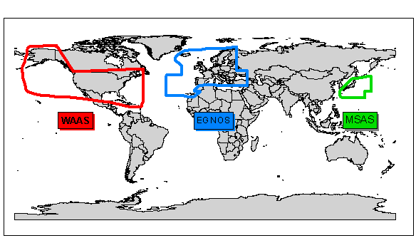
Fig. 1 Availability of the 3 satellite based DGPS systems
Since the 3 systems are compatible international coverage is guaranteed. The systems send their correctional signals at the same frequencies as GPS. Since a modern 12 channel GPS maximally receives signals from 10 satellites, one channel remains free for the reception of correctional signals. The use of the corrected data is charge free for the GPS receivers.
Difference of EGNOS and WAAS to normal DGPS
In the terrestrial DGPS method the individual reference stations calculate their own correctional values on the basis of the received signals from the NAVSTAR satellites and transfer the data via UKW or LW broadcast to the GPS receiver. This corrects its position with the received information. With increasing distance between the two the signal from the satellite to the ground reference station travels through other parts of the atmosphere as the signal from the satellite to the GPS receiver. This makes the correction ever more inaccurate. Typical ranges for transmitters of the reference stations are between 50 – 200 km.
The ground segment of the satellite based DGPS for EGNOS is a network of 34 monitor stations (RIMS; Ranging and Integrity Monitor Stations) which receive the corresponding satellites signals and transfer these to 4 central data processing stations. In these data processing stations a correctional map is calculated from the sum of the measurements of all monitor stations for a total area. This correctional information is then sent to geostationary communicatiion satellites (for ex. AOR-E, IMARSAT, IOR-FS, or Artemis) from where they are relayed to the GPS receivers.
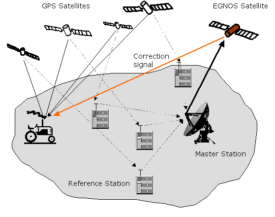
Abb. 2: Principle of EGNOS and WAAS
With the aid of this data every individual GPS receiver corrects its own position. Thus EGNOS and WAAS permit a wider ranging coverage and greater accuracy on land as well as at sea than the terrestrial DGPS systems.
In contrast to the terrestrial DGPS method the GPS receivers do not need any additional LW receivers and the large number of ground reference stations to transfer the signals are rendered superfluous. The worldwide availability of the 3 systems is presented in Fig. 1.
The European Geostationary Navigation Overlay System
EGNOS is operated by ESA (European Space Agency) and by EUROCONTROL the European Organization for the Security of Space Flight. EGNOS was developed by the European commission mainly for civilian air travel, but also with emphasis on agriclutural applications in order to provide higher accuracies in the localization of positions than is attainable through GPS and so to promote precision farming. (Page 9 in the Communication of the Commission for the Integration of the Program EGNOS into the Program GALILEO, 19 march, 2003) Download: http://europa.eu.int/comm/dgs/energy_transport/galileo/doc/com2003_123_de.pdf
Through EGNOS the correctional signals for the DGPS can be broadcast charge free from one satellite over all of Europe. EGNOS will supplement GPS and the GLONASS system.
EGNOS will be integrated into GALILEO, the European satellite navigation system which will go into operation in 2008. GALILEO is Europe’s initiative to the development of a modern worldwide satellite navigation system, that will make available a precise, worldwide position determination service under civilian control.