
The Global Positioning System consists of a set of 24 operational satellites and land-based control stations. The system was designed for and is operated by the U. S. military, owned by the US Department of Defense (DoD). But it is available on a worldwide basis to all civil GPS users with no direct charge.
GPS determines distance between a GPS satellite and a GPS receiver by measuring the amount of time it takes a radio signal to travel from the satellite to the receiver (figure 1). Radio waves travel at the speed of light, which is about 300,000 kilometer per second. So, if the amount of time it takes for the signal to travel from the satellite to the receiver is known, the distance from the satellite to the receiver (distance = speed x time) can be determined. If the exact time when the signal was transmitted and the exact time when it was received are known, the signal’s travel time can be determined.
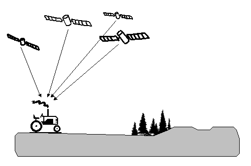
Fig. 1: Principle of the location estimation via GPS
In order to do this, the satellites and the receivers use very accurate clocks which are synchronized so that they generate the same code at exactly the same time. The code received from the satellite can be compared with the code generated by the receiver. By comparing the codes, the time difference between when the satellite generated the code and when the receiver generated the code can be determined. This interval is the travel time of the code. Multiplying this travel time, in seconds, by 300,000 kilometer per second gives the distance from the receiver position to the satellite in miles.
Two carrier frequencies
Each satellite transmits a coded signal on two carrier frequencies that says, amongst other things, where it is in the sky. In its simplest form a GPS receiver receives the signal from the GPS satellite and uses the code to determine its distance from the satellite. If the distance to four satellites can be measured at once then the receiver can calculate its own position in real time. A position calculated in this way is accurate to better than 15 metres.
GPS System Segments
The GPS consists of three major segments: SPACE, CONTROL and USER.
The space segment
The space segment consists of 24 satellites, each in its own orbit 20,200 kilometers above the Earth. The nominal GPS Operational Constellation consists of 24 satellites that orbit the earth in 12 hours. There are often more than 24 operational satellites as new ones are launched to replace older satellites. The satellite orbits repeat almost the same ground track once each day. The orbit altitude is such that the satellites repeat the same track and configuration over any point approximately each 24 hours (4 minutes earlier each day). There are six orbital planes with nominally four satellites in each, equally spaced (60 degrees apart). This constellation provides the user with between five and eight satelites visible from any point on the earth.
The control segment
The Control Segment consists of a system of tracking stations located around the world (figure 2): the GPS Master Control station and several monitor stations.
The Master Control unit, located at Schriever Air Force Base in Colorado, is responsible for overall management of the remote monitoring and transmission sites.
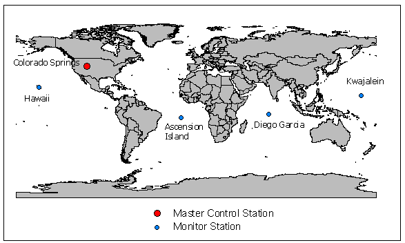
Fig. 2: Location of GPS monitor- and control stations
It measure signals from the NAVSTAR satelites and it calculates any position or clock errors for each individual satellite based on information received from the monitor stations. The “new” corrected data are uploaded by the Master Control station. And at least the NAVSTAR satellites send the new data over radio signals to the GPS receiver back to earth.
The 4 Monitor Stations are unmanned stations located around the world (Hawaii and Kwajalein in the Pacific Ocean; Diego Garcia in the Indian Ocean; Ascension Island in the Atlantic Ocean. They track up to 11 satellites twice a day.
User segment
The user segment consists of GPS-receivers, located in cars, planes or even in GPS collars for wildlife. They can be as small as a mobile phone.
Differential GPS (DGPS)
The accuracy of GPS localizations averages 15 meters. This “inaccuracy” results from the purposeful interference of the GPS systems operator (DoD) with the satellite signals as well as from systems error. Such systems errors include, for example, the inaccuracies built into the GPS receivers’ clocks as well as errors caused by deflection of electromagnetic signals transmitted by the satellites when they enter the atmosphere (ionspheric error, troposphereic error).
With the aid of correctional methods it is possible to improve the accuracy of GPS determined positions. This method is the Differential GPS method. Here correction signals are sent to DGPS receivers which then correct the position errors.
Two methods are used for correction: terrestrial and satellite supported DGPS
In the terrestrial method the correction of position error occurs via exactly surveyed ground stations, so called reference stations, which continually ascertain their position with the signals from the GPS satellites, compare these signals to their actually known position, and from this calculate a corrected value. These corrected values can be transmitted via UKW or LW transmitter to the mobile DGPS receivers at their interface (RTCM format). These in turn can then correct their own position coordinates. The accuracy obtained by this method ranges between 1 – 3 meters, whereby the accuracy depends on the distance to the correctional data transmitter and the signal quality (Fig. 3).
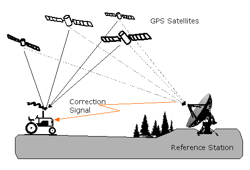
Fig. 3: Principle of the differential GPS for the terrestrial method
Satellite supported methods such as the WAAS (Wide Area Augmentation System) or EGNOS (European Geostationary Navigation Overlay System) send the corrected data via geostationary satellite and thus reach a greater reception area than the terrestrial methods
Do you know the term DOP?