According to BURT (1943) is the home range of an animal “that area traversed by the individual in its normal activities of food gathering, mating, and caring for young”.
In practical the term “home range” of wildlife is used twice: 1. it refers to a map area resulting from location fixes estimates of the animal, and 2. it is refers to an numeric estimate of the area used by the animal, with m2 or km2 as units.
There are several methods to estimate home ranges of wildlife
- Polygon Method – Estimators are derived from peripheral points or from distances between points furthest apart.
- Center of Activity Method – Estimators are derived by assuming a parametric form for the utilization distribution function, and fitting of this form to the activity data or activity radii.
- Nonparametric Method – Estimators are derived by approximating the utilization distribution function using robust density estimators on the geographic coordinates of radio tracking locations or trapped locations.
The polygon method only gives the extent of the animal’s range, whereas the other two methods also address intensity of use.
The oldest and most common method is the minimum area polygon method (MAM) or convex-polygon method (Mohr 1947). In our studies the range sizes were calculated using the convex-polygon method. In this method all locations of an animal are graphically depicted, and the outer position points connected in such a way that a convex polygon is produced (Fig. 1).
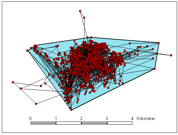
Fig. 1: Determination of the size of a range (blue area) according to the convex-polygon method. Localization points of European wild sheep Nr. 53 connected in chronological order (n=1224) from a GPS tracking project on mouflon
The thus enclosed area corresponds to the home range of the animal. Localization points that are recorded outside of the home range of the animal due to occasional excursions elsewhere would greatly exaggerate the size of the actual range. Therefore localizations that are further than 0.5 km from other points or localizations that are the result of infrequent wanderings are not included in the calculation of the actual ranges.
Home range utilization
Most animals do not utilize their entire home range with equal intensity. Certain areas tend to be utilized more heavily than other areas.
The center of activity is defined as the geographical location within the home range of the point of greatest activity.
Mode(s) of an animal’s area utilization distribution function would also be considered its activity center(s).
The distances from the center of activity to recapture points or radio-tracking locations is called the activity radius.
Example
Fig. 2 shows the utilization intensity of a mouflon ram telemetrized by GPS. It did not use their ranges uniformly, definite intensively used areas within these ranges can be clearly recognized. These intensively used areas are home bases to which the animals regularly return with varying priorities. The Kernel Method (Worton 1987) is particularly suited to the presentation and quantitative determination of such activity densities within the ranges. This method mathematically converts the position coordinates into lines or areaswith varying probabilities of use and presents these graphically. For ram Nr. 32 the use intensities in 10% intervals were calculated with the Kernel Method and the respective areas marked with a different colour (Fig. 2).
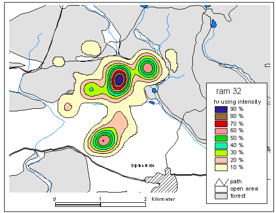
Fig. 2: Home range utilization intensity of the range of ram No. 32
The range was used with varying intensities depending on the season or period of day. Rape and winter wheat fields were only used for grazing from November to March and then only at night. The remaining time of the year the animal stayed in closed forest. The size of the ranges of the investigated wild sheep varied between 549 and 1090 ha.Two of the animals which had originally come from a reserve preferred smaller ranges of 107 ha (ewe) and 412 ha (ram).
Data evaluation with a GIS
The locations of the animals, obtained by GPS telemetry, are stored as Cartesian coordinates. For further evaluation the data are converted to Gauss-Krueger coordinates and transferred as dBase files to a geographical information system. For the construction of the GIS various thematic maps of the investigation areas are digitalized and overlaid with the position coordinates of the investigated animals. The data is analyzed using the software ArcView (Company ESRI ) and Animal Movement Analysis ArcView Extension (Alaska Biological Science Center).
References
Burt, W. H. (1943), Territoriality and home range concepts as applied to mammals. Journal of Mammalogy, 24, 346-352. Textlink
Dixon, K. R. and Chapman, J. A. (1980), Harmonic mean measure of animal activity areas. Ecology, 61(5), pp1040-1044.
Harris, S., Cresswell, W.J., Forde, P. G., Trewhella, W. J., Woollard, T. and Wray, S. (1990), Mammel Rev., 20(2/3), pp97-123.
Kie, J.G., Matthiopoulos, J., Fieberg, J., Powell, R.A., Cagnacci, F., Mitchell, M.S., Gaillard, J.-M., Moorcroft, P.R., 2010: The home-range concept: are traditional estimators still relevant with modern telemetry technology? Philosophical Transactions of the Royal Society B 365, 2221–2231. Link
Worton, B. J. (1987), A review of models of home range for animal movement. Ecological Modelling, 38, pp277-298.