Bear telemetry research: Tracking bears with GPS GSM collars in order to study movement, activity, home range and habitat use.
by Sven Brunberg
Scandinavian Brown Bear Research Project
First pilot study in 2003 with GPS transmitter and two way remote communication via GSM:
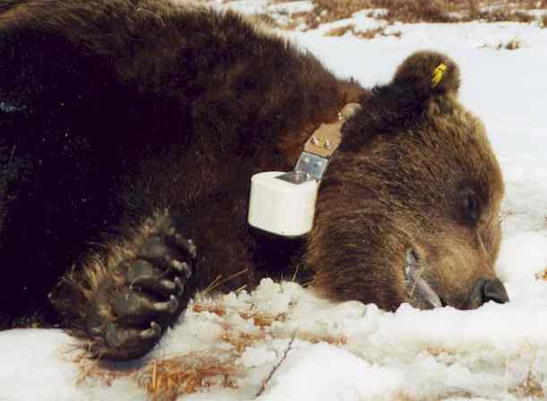
Due to their high mobility, their spatial and temporal behaviour bears are difficult to investigate and ber researach was a hard job. Here satellite telemetry provides the optimal solution. In our team project (Scandinavian wedish brown bear project) we use the newest applied technology: GPS-Plus GSM collars. The bears wear 1.1 kg collars (fig 1.) which determine and save their respective locations via GPS (Global Positioning System). The form of data transmission is new: the locations of the animals are transmitted several times daily via a GSM- modem (Global System for Mobile Communication) integrated into the collar, like an SMS (Short Message Service) sent by mobile phone. The data arrive directly to our office where they are transferred by computer to digital maps.
Bears were fitted with GPS-GSM collars
The GPS-GSM collars of the bears are programmed in such a way that they determine their locations every 30 minutes and send up to seven positions each 3.5 hours as a standard SMS.
Within the scope of the Scandinavian Brown Bear Research Project one adult female and two adult male bears were fitted with GPS-GSM collars in April and June 2003 in order to study it’s movement, home range, activity and habitat use. The investigation area is located in the middle part of Sweden (Fig. 2).
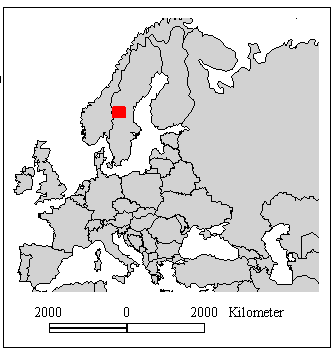
Fig. 2: Location of the investigation area in Sweden (red symbol)
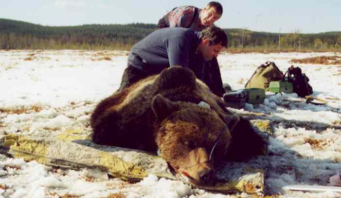
Bears are immobilized from a helicopter with remote drug delivery system
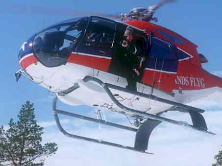
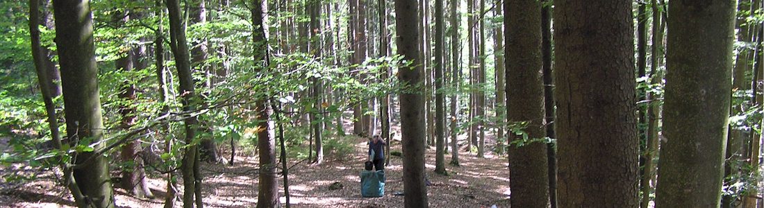
At the “bear house” in Kvarnberg, the base of the bear research, the drugs for the darts and all devices for taking physiological and morphological mesurements become prepared. The darting group is leaving by helicopter, searching for radio signals of marked bears or to find unmarked bears. The team follows by car. If a bear is localized, the helicopter flys up to 5 meters to the bear and he becomes darted by immobilizing gun. It takes 3-10 minutes until the drug effects, then the collaring procedure and research could start. After finnishing, the bear gets an antagonist injection (“antidot”) to take back the effect of the immobilization.
Movements and habitat use
Blome was collared on April 13 and recaptured on September 25, 2003 because the GSM modem was not working properly. The GPS GSM collar was replaced. Figure 2 shows the transmitted positions of the nine year old male bear, “Blome”, fitted with a GPS-GSM collar on April 13, 2003, and Löva, a female collared on June, 25, 2003. The localization points are linked in chronological order. The bears mated in June, 2003.
Since bears are hunted there illegally as well as legally, this area will not be localized in further detail.
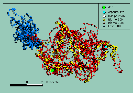
and Blome 2003 (April 13 – October 30, n=7423), Bome 2004 (March 17- May. n=697)
For 2004 we decided to present only the movement of Blome. If in the case of poaching one of the bears will be found, the location of the other one is easy to find out with the map.
Bloome spent the winter in the den from November 12, 2003 until March 17, 2004.
From April 13 until July 27 2003, Blome moved in average 410 m between two following positions (30 minute GPS schedule). Altogether he covered a path of 1738 km. Where many positons are densely clustered the bear probably sleeps/rests or feeds.
How bears behave after immobilization
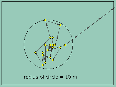
Until now it is not known, how bears behave after immobilization, because the crew flys out after the bear is awake. Trying to get more knowledge about this, we programmed a GPS fixing schedule to take positions all 5 minutes the first 3.5 hours. The bears movement during this time is shown in figure 3. The yellow symbols show positions taken on April 13, 13:20 until 16:55. Obviously the bear moved just 150 meters after leaving the place of immobilization, took a short rest before he moved some more meters. Altogether the movement after immobilization is rather reduced.
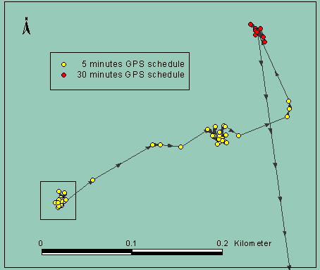
Fig. 4: Enlargement of the rectangle in fig. 2 (capture site): bears movement immediatly after immobilization
Figure 5 shows the accuracy of the GPS locations: The positions from 13:20 until 14:50, the time of immobilization. Obviously all positions are within a 10 meter radius.
GPS collar statistics
The collar took 86% of the possible fixings, nearly all in 3 D class . That means the GPS used signals from at least 4 satellites to estimate a position.
The mean DOP value (Dilution Of Precision, a description of the contribution of satellite geometry to the uncertainty in a position fix) of 2.35 indicates a high probability of a high accuracy of the taken position.
Statistics from April 13 – July 4 for Blome, 2003
| Collar statistics | |
| Fixings possible | 3942 |
| Fixings via SMS transmitted | 3390 (=86%) |
| of that: 2D | 5 |
| 3D | 3385 |
| Mean DOP value | Feb 35 |
| Fixing/SMS efficiency | 98% |
| Bear’s statistics | |
| Max. distance between 2 positions [km] | 7.0 |
| Mean distance of all positions [km] | 0.4 |
| Total travel Distance [km] | 1387 |
| Home range 95% Kernel [km2] | 795 |
| Home range (MCP) [km2] | 1321 |
The data is analyzed using the software ArcView (Company ESRI) and Animal Movement Analysis ArcView Extension (Alaska Biological Science Center).
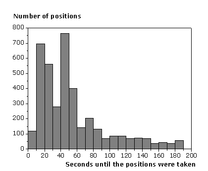
GPS-fixing time
Figure 6 shows a histogram of the time, the GPS-receiver needed to find and record the location of the bear from April 13 – June 12, 2003 (n=2932). About 70% of the positions have been determined in less than 60 seconds and 86% in less than 100 seconds.
Bears activity
The complete GPS data sets and the activity and temperature data sets from the tracking period April 13 to September 25, 2003 have been stored on board of the GPS GSM collar and were outried by computer via Link Manager. The activity of Blome are shown in figure 7 and 8.
The activity of the bear has been monitored by a two axis activity logger. By this, the acceleration of the collar will be estimated 6-8 times every second and the overall mean value has been stored every 5 minutes. At least 47520 data sets have been stored on the collar.

Fig. 7: Activity data of Blome in x- and y direction (blue and green symbols) and temperature data (red line), April 13 to September 25, 2003 (n=47520 data sets each)
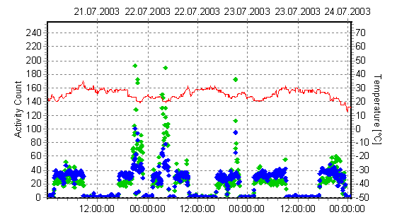
Fig. 8: Detail of Blomes activity in x (blue symbols) and y-axis (green symbols) and ambient air temperature (red line), from July 21 – 24, 2003
Author Sven Brunberg
sven.brunberg@bearproject.info
Literature
Capture, Anesthesia, and Disturbance of Free-Ranging Brown Bears (Ursus arctos) during Hibernation
Research killed and maimed several bears
NJ Biologists Use GPS Collars to Track Bears
A new GPS-GSM-based method to study behavior of brown bears